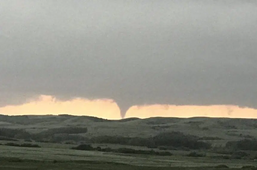
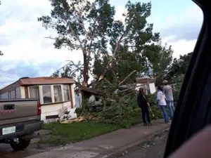
At least four tornadoes touched down Tuesday in southwest Saskatchewan.
The first reports of wild weather came in around 3:45 p.m. when a tornado was reported north of Maple Creek near Golden Prairie, which is close to the Alberta border.
About two hours later another funnel cloud was spotted touching down south of Swift Current near Val Marie.
Two more tornadoes touched down between 6:25 p.m. and 6:45 p.m. southwest of Moose Jaw near Wood Mountain.
It was the second day of extreme weather for the southwest region, with two confirmed tornadoes and reports of a third on Monday. Saskatchewan did not see any major damage from those storms, but it was a very different story south of the border in Plentywood, Montana where tornadoes ripped the roof off a house, tore trees up from the roots, destroyed trailers and threw small planes around like toys.
Wednesday was expected to bring a reprieve from wild weather as extreme heat and storm warnings were all lifted.
Environment Canada recorded wind speeds between 90 and 130 km per hour but did not receive any official reports of damage. Anyone with information on severe storms is encouraged to report it by email to ec.storm.ec@canada.ca or by phone at 1-800-239-0484.
The severe weather led many in the southwest corner of the province to take to social media with pictures of large hailstones and tornadoes spotted over the course of the day.
Monster hail from a storm east winds of Val Marie #skstorm 502pm pic.twitter.com/FBw8CyRlmI
— Craig Boehm (@Skstormchaser) July 10, 2018
Tennis ball-sized hail in Val Marie not too long ago. #skstorm 533PM pic.twitter.com/MLgHP2tK0r
— Kyle Brittain (@KyleTWN) July 10, 2018
Wedge tornado south of Wood Mountain 6:50. #SKstorm @PrairieChasers @BraydonMoreSo pic.twitter.com/nMVmqlkaNo
— Sean Schofer (@SeanSchofer) July 11, 2018
Calling it chase. Several tornadoes documented and reported. Wild ride. Media requests can be directed to @PrairieChasers for video and photos. DM us.
Pic from earlier tonight near Wood Mountain SK
Thanks to the meteorologists who continue to warn these storms. #skstorm pic.twitter.com/cRAYjL9x6g
— Prairie Storm Chasers (@PrairieChasers) July 11, 2018
Tough chase day for me. Made some bad calls and put myself in bad positions for pictures. Should have just driven to my initial target Wood Mountain, SK. Caught this there. #skstorm pic.twitter.com/Tf89xGuKIt
— Craig Hilts (@CraigHilts71) July 11, 2018
Thunderstorm pounds Kindersley
While southwest Saskatchewan dealt with hail and tornadoes, many in the central part of the province also experienced some wild weather.
A thunderstorm rolled through the community of Kindersley, with pictures posted to social media and sent in to 650 CKOM showing damage apparently caused by high winds.
The Kindersley Fire Department reported responding to a number of incidents over the course of the evening, with the Red Cross available to help those in need.
Kindersley, SK #skstorm pic.twitter.com/eKnDfJNEaz
— smilin always (@imaknockuout) July 11, 2018
It did look fearsome, but I never imagined it would blow THAT hard, yikes! pic.twitter.com/7pvitZLuQz
— Hank Vlietstra (@FlatlanderHank) July 11, 2018
Meteorologist Shannon Moodie with Environment Canada said they recorded peak gusts of 89 kilometres per hour in Kindersley during the storm.
She said staff at the weather service would be calling around the area Wednesday to get better data on damage caused by the storm.
Moodie said the severe weather throughout Saskatchewan was caused by a cold front moving west-to-east across the province.
She said the cold air was expected to continue flowing into Manitoba Wednesday, with parts of east-central Saskatchewan potentially seeing more storms.
“You could get some localized heavy rainfall up to 40 millimetres in thunderstorms,” she said.
Moodie said the storm activity could produce some funnel clouds, but they are expected to be weaker than those spotted Tuesday and unlikely to touch down.


